First VK3 SOTA activations!
Ever since I first got into ham radio, I have been drawn to the QRP and homebrewing aspects of it. When I eventually learned about Summits On The Air, the overlap of ham radio with my enjoyment of hiking and camping was irresistable. In Summits On The Air, or SOTA, each participating region has an Association run by volunteers who determine what summits qualify and how many points they will get. Activators qualify a summit by making four contacts from it; “chasers” earn points from home for making the effort to complete a QSO. I first got into SOTA when I lived in San Francisco, but I only managed two successful one-point activations over a three-year period there.
When I moved to Melbourne, Australia, I naturally wanted to get connected with the ham community here. I first made contact with Paul, VK3HN, via mutual Twitter acquaintances. We soon took our conversation to WhatsApp, and over the ensuing months Paul provided lots of encouragement as I organized to get my VK license. Then we discussed antenna options, looking for something that would fit in my very small city house lot. I can’t put anything on the roof, so I just have a small scrap of yard in which to try and string up a wire antenna. Paul suggested a simple end-fed designed by Glenn, VK3YY, and it seemed to fit the bill. Since I didn’t have a 240v soldering iron yet, Paul offered to whip up the match box and antenna wire with coil for me. We had our first eyeball QSO when he handed that off to me a few months ago.
All of that sets up the story of my first VK3 SOTA activations. My friend Nick, veteran of many ambitious camping expeditions, was coming to visit from California for two weeks. I decided to organize a camping trip during his visit, so we could both see some of the Australian bush. I posted to the Australian SOTA mailing list to solicit advice about possible destinations, and eventually settled on Paul’s suggestion of a two-day trip to Mount Buffalo National Park. Day one would see us drive four hours to the Lake Catani campground, a drive-in spot with amenities at hand. From there we could activate two summits, The Horn and The Hump, on the same afternoon. On day two we would hike up to Mount McLeod, camp off the grid there, and activate the McLeod summit. Then hike back and drive home on day three. This would net me 30 activator points to add to my existing two! The radio gear would be my KX3 with ATU, a new 4Ah LiPoFe battery, the end-fed antenna, and one of my 20 foot telescoping fiberglass poles. My Morse speed was a pokey 8wpm when I last used it six years ago, so I planned to use voice only.
On Wednesday we made good time up to Lake Catani, and headed directly to The Hump in order to make my predicted 4pm activation time. We nipped up to the top in ten or fifteen minutes, got the station set up quickly, and I spotted myself using the SOTA Spotter app. Starting out on 40 meters, VK4TJ was the first contact in the log, followed by VK4NH, VK2UH, VK2IO, and VK2HRX. A chaser suggested I try 20 meters to pull in some ZL chasers, so we switched bands and netted VK3SQ and ZL1BYZ. By this time it was already 5pm, so clearly my estimate of activating one summit and moving to another (admittedly nearby) within an hour was far too optimistic. We packed down and moved to The Horn, again a quick climb from the car park. We strapped the squid pole to the railing at the very top, strapped the match box to a railing at a lower point from there, and set up the KX3 on a convenient rock. We were on the air by 6:20pm, and quickly worked VK2LEE, VK4TJ, and VK2IO on 40m. With no further calls we switched to 20m after ten minutes, and worked ZL2AJ to complete the activation. A few more minutes of CQ yielded nothing, so we packed down and were back to the car around 7:15pm.
On The Horn
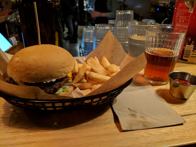
We had planned to eat dinner at the pub in Porepunkah, about an hour’s drive from The Horn, and as we were already a bit hungry we headed directly there, planning to set up camp in the dark when we returned. Unfortunately, when we arrived we found that the pub was closing up for the night, so we headed to a place called Tomahawks in Bright. It didn’t take long to order two burgers and two beers, and we toasted our successful day and enjoyed the atmosphere at the bar. There was a stuffed buck’s head mounted on the wall, and Nick asked me, “Are there deer in Australia??” I wasn’t sure, but knew that other game animals had been introduced for hunting purposes, so I thought it was possible that deer had been as well. We headed back to Lake Catani in the dark.
An excellent hamburger
I’ve driven on unlit country roads enough times to know to keep my eyes peeled for wildlife darting out in front of my car, so when Nick let out a yelp, and I saw movement in my peripheral vision, I locked the brakes almost instantly. That’s how we confirmed that yes, there are deer in Australia, and since I didn’t hit this one, their numbers remain steady. Further along the road, another dark mass darted out, and may have bumped the rear of the car, but we couldn’t make out what it was. Wombat, maybe? Perhaps not, I’ve been told they don’t “dart.” Finally we arrived at camp, got our tent set up with no trouble, and even found that someone had left the embers of a fire burning in one of the communal fire pits. We threw in a couple of small branches and warmed ourselves beside it while admiring the stars, before turning in for the night.
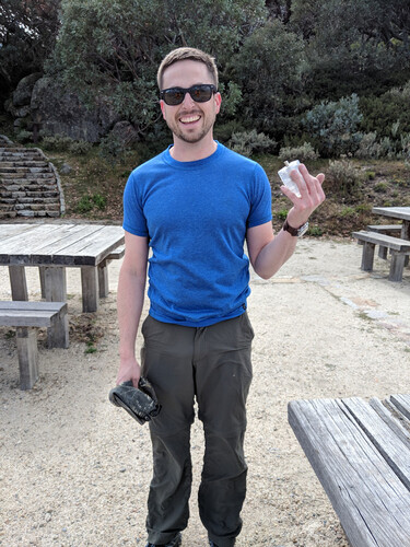
The next morning we got up, had a quick breakfast and coffee, and then packed down the tent. The plan was to drive to the Reservoir picnic area car park, then hike from there to Mount McLeod. In the process of re-packing just the essentials needed for one night, Nick said, “Where’s the match box?” Where indeed? A search commenced, but it didn’t take long to conclude that we had left it strapped to a fence railing on The Horn. Well, better to figure this out now than after a hike of several hours. We drove back to the Horn car park, and Nick said, “I’ll just trail-run up there and grab it.” Well, if you insist… He was back in ten minutes, match box in hand. Hoorah!
Match box retrieved
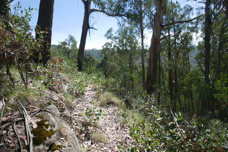
Soon we were on the trail to Mount McLeod. It is listed as an 8 km hike, and we anticipated 2.5 to 3 hours cover it. Not long down the fire road track we came to a sign which advertised a shortcut. Never ones to turn down such an offer, we took it, but it wasn’t long before I was having second thoughts. The trail was clear enough, but very narrow and overgrown. In some places, downed trees had been cut through, but there were others that we had to clamber over. I was regretting my heavy hiking boots and bulky sleeping bag strapped to the outside of my pack. I felt like I was stumbling rather than hiking. I grumbled to myself that we would skip the shortcut on the way back and stick to the fire road.
Shortcut trail, one of the better parts
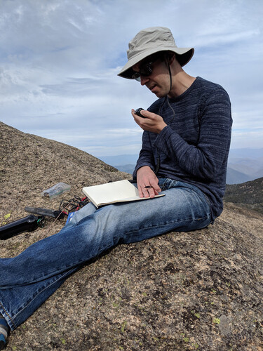
Not being familiar with the area, we encountered a couple of false summits along the way, thinking, “Surely we’re nearing the top of something.” Well, that much was true, but not the top of the thing. Finally we arrived in the alpine meadow at the base of Mount McLeod, where the bush camping area is. To our surprise, there were two 4WDs parked there, but no one around. We pitched our tent, then headed for the McLeod summit. The climb up was more of a rock scramble than I expected, and trying to do it while holding a water bottle in one hand and a squid pole in the other seemed like physical comedy. We reached the summit at about 4:30pm local time and were soon on the air, making first contact with VK2IO, then VK2HRX and VK5IS all on 40m. Then I moved to 20m and netted ZL1BYZ, and finally tried 80m and managed to work VK3PF closer in. I wasn’t able to work any other VK3 stations on 80, although Paul, VK3HN was listening. He and I were “QRL 1800 MHz,” using WhatsApp to discuss conditions. We set up a schedule to attempt contact on 80 later when I was back at camp.
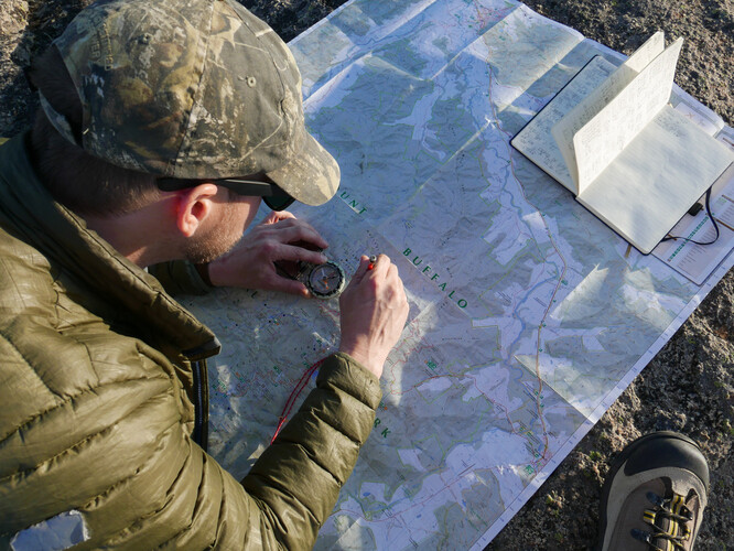
After finishing the activation, we drank celebratory beers, and then debated whether to watch the sunset from the summit, or head down before it got too dark. Nick gave me a short tutorial on orienteering, using our topo map and his fancy Suunto mirror compass. We identified some geographic features around us, Nick showed me how to take a bearing, and then had me do one for each feature. The lines from each one converged neatly on our actual position, within about 20 meters or so! After this we decided it would be preferable to head down before sunset, and did so.
Back at camp, the 4WDs that had been there before were now gone; we hadn’t seen their occupants. Nick cooked biryani on the camp stove while I set up the station again for my schedule with Paul. At the appointed time Paul came up, first on CW (but I didn’t have a key), and then clearly on SSB, but he was unable to hear me at all. We tried 40 and 20 meters as well, without success. We had thought it was likely that we would see a wallaby or wombat or the like in the meadow near our camp site, but were disappointed. We consoled ourselves with the spectacular stars, and then turned in as it was getting chilly. Paul had mentioned that the overnight low was forecast to be 3C, and I suspect it was about that. I woke up once or twice in the night, feeling cold, and remarked the next day that my sleeping bag is rated to -6. Nick pointed out that it means, “keeps you alive down to -6,” not “keeps you toasty warm.”
Plotting our position
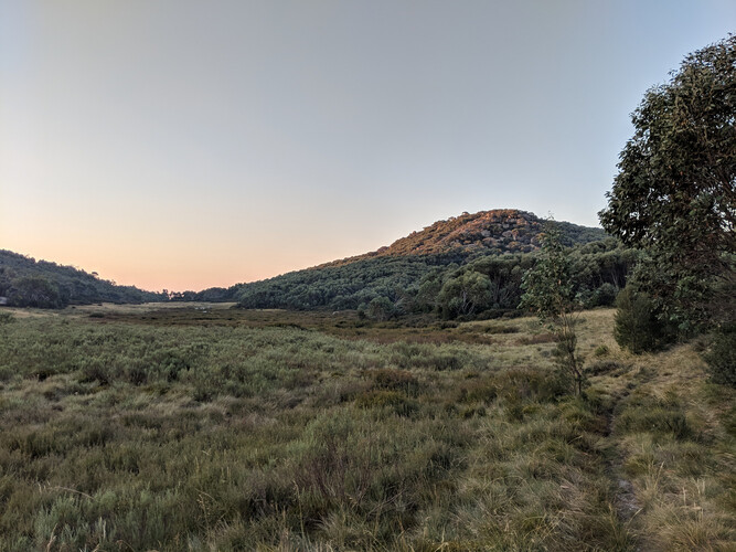
The meadow at sunset
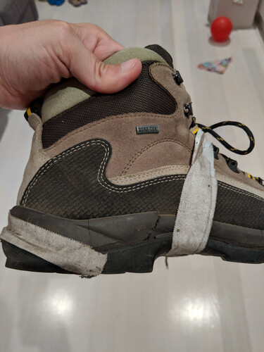
In the morning we broke camp and prepared to head out. Upon reaching the McLeod summit the previous day, I had discovered that the sole of my right boot had almost completely delaminated, and the left one was clearly not far from doing the same. I was kicking myself for choosing these 14-year-old hiking boots, rather than taking Nick’s advice and just wearing runners, but I had figured I would prefer their heavy soles on the rocky trail. But in addition to falling apart on me at an inopportune time, they’re heavy and they don’t breathe, making for uncomfortable feet after hours of hiking in warm weather. I taped up the flapping sole with medical tape and then we hit the trail.
We weren’t far down it before we met the same two 4WDs coming the opposite way. The first stopped to chat, and the driver said they were botanists working on eradicating invasive weeds. Friendly guy, asked us if we were all right for water and so on, then headed on. Next we encountered some bush walkers, scouting the trail for a possible larger group outing in the future. We mentioned the trail shortcut, which we had determined only cut off .5 km from the route, and I said we were thinking of skipping that for the way back. These folks advised us not to, saying that the main trail has a significant ascent and descent at that point, and the shortcut cuts that out completely. We took their advice, and finished the hike in about three hours. My left hiking boot failed about 100m from the end, but the medical tape held up perfectly on the right one.
Into the bin
After a quick stop at Lake Catani to change clothes, we hit the road back to Melbourne, trying to get there in time for dinner, which we did. My wife asked us to stop and pick up pizza near home, and I imagine we looked a sight walking through the door of the take-away shop. They didn’t pass comment, though.
In the weeks leading up to the trip, I chatted to Paul a few times about details, and he gave me some advice culled from his years of experience in the Aussie bush. At the end he said, “A memorable camping experience awaits!” He wasn’t wrong, and I’m grateful to him for all his suggestions and trail support. I’m also grateful to the folks on the OzSOTA mailing list who offered their tips and encouragement, especially those who made time to chase me on weekday afternoons! Finally, I’m really glad that Nick, with his experience of numerous epic camping adventures around the US, was there to back me up. Not only is he an excellent friend in general, but with him along I didn’t have to worry that I would forget something crucial or get into anything over my head.
What would I do differently next time? Reduce weight. In my pack I carried half the tent, half the food, clothes for one night, my sleeping bag and pad, the radio gear (minus squid pole), and two liters of water. Nick carried everything else, including ten liters of water. My sleeping bag is pretty ridiculous: it is sized for a 6’6” person (I am 5’9”), and has the approximate weight and dimensions of an adult Corgi. Before my next trip I’ll get a new bag which could be 1/2 the weight and 1/4 the size. Likewise, I am newly motivated to sharpen my CW skills, so I don’t have to tote the KX3 and a 4Ah battery. I already have a KD1JV ATS-4 radio, which weighs 180 grams compared to the KX3’s 800. It may only output half the power, but with the signal strength gain of CW over SSB, it probably still wins. I could cut my battery weight by half or more as well. Next time I’ll go with trail runners, rather than boots, unless I anticipate water or snow. Otherwise, I think I did pretty well!
At some point after the trip I said to Nick, “There were times when I was grumbling to myself on the trail: my feet were sweaty, my hip was sore, my pack was heavy, and I was tired. But I knew I could just keep trudging on, and I did.” He shared his philosophy on fatigue, which is that tiredness is a spectrum. Every time you push yourself, you learn that you can do more, go further, and the muscles will keep going. When you first start out hiking, the rapid improvement in endurance that you see first comes from learning that you don’t really know what “tired” is yet. Now I’m looking forward to pushing that boundary forward for myself.
A gallery with more, larger photos from the trip is here.